Add GPS Information to EXIF Images
Posted by john, 10:10, Monday 08 September 03.
A step by step guide on how to add GPS information into EXIF images using Photo Studio.
 Step 1
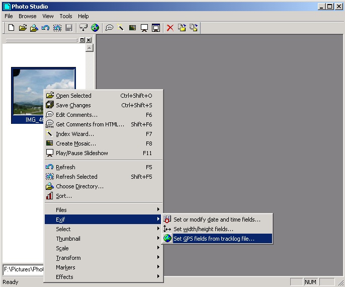
Select the directory where your image(s) reside in the browse window. That's the left hand pane which shows you thumbnails. Then, right-click on the image(s) you wish to add GPS information to. This then gives you the browse popup menu, which hopefully you can see in the screenshot. From this menu, go to the Exif sub-menu and choose "Set GPS fields from tracklog file..."
 Step 2
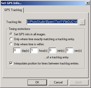
The "Set GPS Info..." dialog should appear. If you take a look at the picture, you can see which settings I've used in this test run. Obviously as well, it is important to specify here the correct file name and path of your GPS tracklog file. When all the settings are correct, click OK.
 Step 3
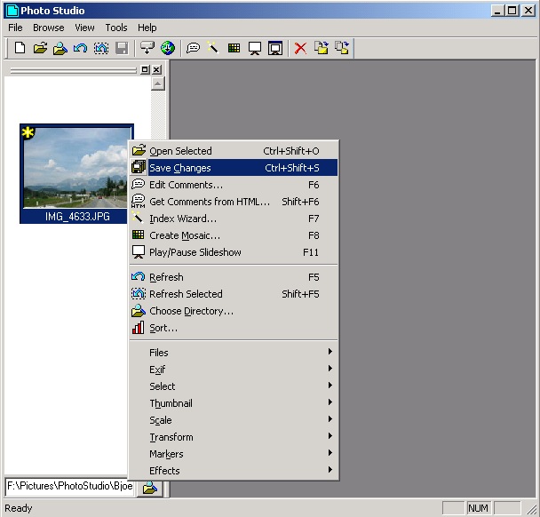
This is the bit that usually causes confusion, and I admit I am not an expert in good interface design! Some actions applied to images in the browse window don't actually get written to the file immediately. Whenever a little yellow star appears on a thumbnail in the browse window, it means the image has been modified, but these changes have not been saved yet. (Hopefully this little star should be visible in GPS3.jpg). So, it is necessary to right click on the selected image(s) and choose "Save Changes" from the browse popup menu. After a few seconds (or maybe straight away if you have a fast PC) the star(s) should disappear, meaning your images have been saved.
 Step 4
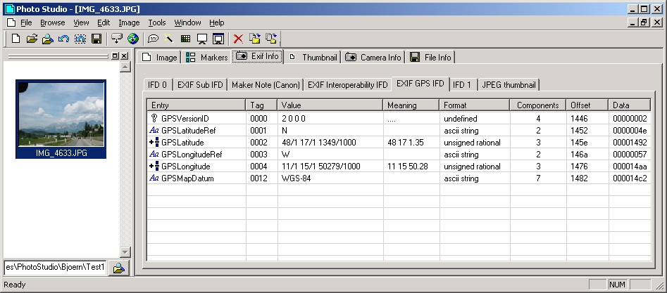
You should now be able to double click on your image, click on the EXIF tab, then click on the EXIF GPS IFD tab, and there is your GPS information!
Notes
You may find this Example GPS Tracklog file useful. This is nn example tracklog file that should work with the GPS feature. It was generated using G7ToWin. Saved using Old Text File format, with Degree Display Mode set to DD MM SS.ss.
Comment 1:
The standard G7ToWin (*.g7t) format, with Degree Display Mode set to DD MM SS.ss, works also fine!
Posted by Werner Stein, 17:51, Friday 10 October 03
Comment 2:
The results calculated for the interpolated positions gives strange numbers sometimes.
Ex: 45ş33'1.92" give 754974720/16777216 553648128/16777216 1879900160/16777216
I would like to be able to display GPS data in various formats ex: 45ş15'43.30" or 45.26369444ş or 45ş15.82166666'
Posted by Michel, 01:49, Monday 27 October 03
Comment 3:
Hello John,
i use Photo Studio with great pleasure, because it´s a very good program.
To improve them a little bit, i had the following suggestion:
The most of GPS-Mice (also Bluetooth-GPS-Mice) don´t have a Tracklog-feature so you aren´t able to create an input-file for Photo-Studio :o(. But a brand independend log-file of the NMEA-output can easily be taken with nearly every GPS-device by using a terminal-Program such as Hyper-Terminal or a map-Program. The most GPS-Dataloggers (I use the Royaltek RBT3000) are also capable to write NMEA-log-files.
Is it possible for you, to add "EXIF-> Set GPS-Field´s from NMEA-File"? It would be great!
If you do this, don´t forget an input like "Time-difference between UTC an Photo-Time" because Photo-Time is normally Local-Time (Summer-/ Wintertime) and GPS sends only UTC.
I suggest "RMC" sentence for the Time, date, Latitude, and Longitude and "GGA" (if sent) for the Altitude.
If you need forther Information, sample log-files or something else, don´t hesitate to contact me.
Kind regards,
Manfred Detterbeck.
Now, some additional information about NMEA for you:
http://www.gpsinformation.org/dale/nmea.htm
http://www.nmea.de/nmea0183datensaetze.html
http://www.silcom.com/%7Erwhately/page1.html
NMEA-183 Ver 2.0 GPS Sentence Compatability
By Jack Yeazel
(Compares map requirements Vs. receiver outputs)
# (Revised 28 Sept. 1998)
[$GP* Sentences - $PG* Sentences not included]
Many people wonder why their brand of GPS receiver won't work
with one or the other map programs. The reason is that ALL NMEA-
0183 DATA STREAMS OUTPUT BY VARIOUS GPS RECEIVERS ARE NOT THE
SAME. NMEA-0183 version 2.0 and earlier protocol versions list
a number of "sentences" which can be output by a navigation
system. Many of the sentences produce similar information in
slightly different formats. This is done so as to maximize
compatability with older equipment while providing the necessary
information in newer sentences for new applications.
Here is information about what NMEA-0183 "sentences" are
delivered by common GPS receivers and what "sentences" are needed
by various common GPS related software.
Note: If your map software (such as Street Atlas 5) requires data
sentence GGA, and your GPS (such as the Magellan 3000) does not
output GGA, then they will NOT work together.
RECEIVERS:
* Required by Street Atlas 4.0 and all supplied by receiver
Eagle Explorer Ver. 1.1, 1.2, 1.3 and Eagle AccuNav
Outputs: APB, GLL, RMB, RMC
Eagle Explorer Ver. 1.4
Outputs: APB, GGA*, GLL, GSA*, GSV RMB, RMC*,
Eagle Expedition II Ver. 3.00
Outputs@: APB, GGA*, GLL, GSA*, GSV, RMB, RMC*
@ Selectable
Garmin-45 (and XL)
Outputs: BOD, GGA*, GLL, GSA*, GSV, RMB, RMC*, RTE, WPL
#Garmin-48
Outputs: BOD, GGA* GLL, GSA*, GSV, RMB, RMC*, RTE, WPL
Garmin 12XL Ver. 3.02
Outputs: GGA*, GSA*, GSV, RMB, RMC*, RTE, WPL
Garmin 12XL Ver. 4.00
Outputs: BOD, GGA*, GLL, GSA*, GSV, RMB, RMC*, RTE, WPL
Garmin G-II+ Ver. 2.04
Outputs: BOD, GGA*, GLL, GSA*, GSV, RMB, RMC*, RTE, WPL
Garmin G-III Ver. 2.04
Outputs: BOD, GGA*, GLL, GSA*, GSV, RMB, RMC*, RTE, WPL
Garmin eMap Ver. 2.50
Outputs: BOD, GGA*, GLL, GSA*, GSV, RMB, RMC*, RTE, WPL
Lowrance GlobalMap Sport
Outputs: APB, GGA*, GLL, GSA*, GSV, RMB, RMC*
#Lowrance GlobalMap 100
Outputs: APB, GGA*, GLL, GSA*, GSV, RMB, RMC*
Magellan 3000, 4000
Outputs:
Mode "A": APA, BWC, GLL, VTG
Mode "B": RMB and RMC
Mode "C": APB, BWC, GGA, GLL, VTG
Magellan NAV 5000DX add:
Mode "C": BWC, GLL, VTG, XTE
Mode "D": APB, BWC, GGA, GLL, VTG
#Magellan 2000XL, 4000XL, M-315/320 and #ColorTrak
Mode "1.5 APA": APA, BWC, GLL, VTG
Mode "1.5 XTE": BWC, GLL, VTG, XTE
Mode "2.1 GSA": APB, GGA*, GLL, GSA*, GSV, RMB, RMC*
Magellan Trailblazer
Outputs: APB, BWC, GGA, GLL, RMB, RMC, VTG
(Requires Delorme driver for SA4 and MNG)
Trimble Scoutmaster
Outputs: APA, APB, BWC, GGA*, GLL, GSA*, GSV, RMB
RMC*, VTG, WCV, XTE, ZTG
SIRFII-Based GPS-Mice (Rikaline, Holux, Royaltec, RoadNavigation...):
NMEA 0183 Version 2.2 ASCII output -- GGA, GLL, GSA, GSV, RMC, ZDA and VTG.
Posted by Manfred Detterbeck, 13:18, Tuesday 17 February 04
Comment 4:
If you have GPS-tagged photos, add them to our world-wide database of geo-coded photos, where other like-minded folks are covering the globe with photos: http://wwmx.org
Thanks!
Posted by WWMX, 17:54, Tuesday 17 February 04